Image: NASA, CC BY 3.0, via Wikimedia Commons
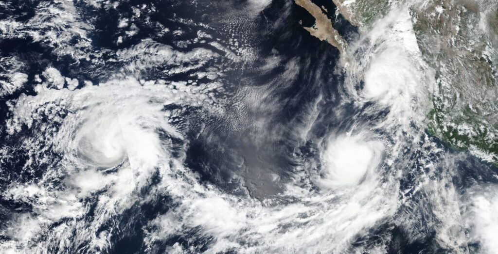
The Eastern Pacific is certainly stirring this September, with not one, but two named systems making waves – or rather, making forecasts. We’re talking about Hurricane Kiko, a behemoth out in the open ocean, and Tropical Storm Lorena, which is currently flirting with Mexico’s coast but could bring some serious sogginess inland for parts of the U.S. Southwest. Basically, it’s a busy week for forecasters and coastal residents alike.
Tropical Storm Lorena: Mexico’s Problem, Southwest’s Concern?
Let’s start with Lorena. She’s been quite active, officially becoming the 12th named storm of the Eastern Pacific hurricane season. Right now, she’s just under 200 miles off Mexico’s western coast, but don’t let that calm facade fool you. By Wednesday, Lorena could very well hit hurricane strength.
The plan (or rather, the forecast) has her center staying west of Los Cabos before a projected landfall much further north up the Baja Peninsula, likely late Friday or early Saturday. Expect her to be a tropical storm by then. Still, Mexico’s Baja California Sur is already under a tropical storm watch, bracing for gusty winds and, more significantly, a lot of rain. Forecasters are talking about bands of heavy rainfall spreading across Baja, potentially dumping 5 to 10 inches, with some spots seeing up to a whopping 15 inches by week’s end. This kind of deluge is a recipe for flash flooding, washed-out roads, and even mudslides.
Now, here’s where the U.S. comes in. Even though Lorena herself isn’t expected to make landfall on American soil – she should fizzle out over northern Mexico – her remnants are looking to send a significant amount of moisture north. That means parts of Arizona, New Mexico, and Texas could be looking at some soaking rain by the weekend. Whether it’s just a sprinkle or a full-on downpour will depend on a high-pressure system currently sitting over the Southwest. If that system weakens, we could see some proper heavy rainfall and localized flash flooding across the Desert Southwest.
Hurricane Kiko: A Distant Threat, For Now
Further out in the vastness of the Eastern Pacific, we’ve got Hurricane Kiko. This one’s a bit of a monster, already a Category 2 hurricane as of Tuesday afternoon, churning more than a thousand miles from Mexico. And the news isn’t getting any smaller: Kiko is actually expected to strengthen.
AccuWeather Lead Hurricane Expert Alex DaSilva put it plainly: “Hurricane Kiko will be entering an area where atmospheric conditions are conducive to strengthening. It is not out of the question that Kiko can reach major hurricane status over the coming days.” We’re talking about peak sustained winds possibly hitting 115 mph by September 3rd or 4th.
For the immediate future, Kiko isn’t expected to pose any land threat. But here’s the kicker: Hawaii needs to keep a very close eye on this. While her five-day track currently shows no direct threat, if Kiko does track closer to the Hawaiian Islands, residents and visitors could start feeling impacts – things like tropical downpours and gusty winds – by the middle of next week. Regardless of the precise path, everyone in Hawaii should definitely expect increased surf and some really strong wave action. Best to stay updated, just in case.
A Lively Pacific, and a Peek at the Atlantic
So, the Pacific is definitely showing off its muscle right now. And just to keep things interesting, experts are also tracking another area south of Mexico for potential tropical development over the upcoming weekend, which, if it forms, would be named Mario.
Not to be left out, the Atlantic has its own thing brewing. A tropical wave hanging out south of the Cabo Verde Islands is looking more and more likely to become a tropical depression later this week. The National Hurricane Center gives it a 70% chance of forming into something more substantial over the next seven days. If it gets a name, it’ll be Gabrielle.
September has definitely brought a surge of tropical activity, reminding everyone from Mexico to Hawaii that hurricane season is very much in full swing. Keep those alerts on!

